Friday, August 26, 2011

Spatial literacy and things to look at.


Left image: Madang estuary.
Right image: Port Moresby harbour.

Related sites to the Spatialworlds project
Spatialworlds website
21st Century Geography Google Group
Australian Geography Teachers' Association website
'Towards a National Geography Curriculum' project website
Geography Teachers' Association of South Australia website
Email contact
manning@chariot.net.au

Where am I??
Adelaide, Australia: S: 34º 55' E: 138º 36'


Spatial literacy:
Some more reading and ideas about spatial literacy.

* Spatial thinking Powerpoint from Bednarz, R., Jo, I., Metoyer, S. (2008) Spatial
Thinking Research at Texas A&M University. Some great synthesis and diagrams to help explain the nature of spatial literacy.

* Spatial Literacy Pathfinder

* New Spatial Literacy course in US

* Spatial thinking book

* Great for risky geography: The latest Terrorism Risk Index (TRI), released by risk analysis and mapping firm Maplecroft, rates 20 countries and territories as ‘extreme risk'.*

* The nine VAACs (Volcanic Ash Advisory Centers)
have been designated by the International Civil Aviation Organization to provide their expertise to civil aviation in case of significant volcanic eruptions. The centres are a basic part of the IAVW. (International Airways Volcano Watch)

* An interactive map of all agglomerations of the world with a population of 1 million inhabitants or more

* Space Shuttle cockpit: No reason but just having a look.

* Sustainable futures talk by Lex Steffen.

* Great blog on GIS in education and curriculum integration. Plenty of linked resources and sites.

* Visualising geospatial data in 3D. DataAppeal is a recently launched web-based visualization application which enables users to produce three- and four-dimensional data maps and animations. It is based on concepts emerging from the 2010 book "The Exposed City: Mapping the Urban Invisibles" by Dr Nadia Amoroso

Tuesday, August 16, 2011

Mick Law: the Australian GIS go-to-man


Left image: Approaching Port Moresby area from the air.
Right image: Coral reefs between PNG and Australia.

Related sites to the Spatialworlds project
Spatialworlds website
21st Century Geography Google Group
Australian Geography Teachers' Association website
'Towards a National Geography Curriculum' project website
Geography Teachers' Association of South Australia website
Email contact
manning@chariot.net.au

Where am I??
Sydney: S: 34º 0' E: 151º 0'


Mick Law: Contour Education: Championing for Australian GIS education

Many of us know Mick Law for his work over recent years providing GIS professional learning opportunities for teachers. Whatever conference one goes to, where geography teachers gather, Mick is there with his banner and table showcasing the great GIS classroom resources he has developed for schools. Mick is an ex-Brisbane geography teacher who made the plunge several years ago to establish his GIS education business after working for a year with ESRI Australia. Mick has written a wide range of targeted classroom activities and placed them on his website at http://www.contoureducation.com/ for free use by teachers. Here are just some of Mick’s resources:

* Spatial from Scratch Booklet
* Advanced GIS Georeferencing Overview
* GIS GPS
* Geoscience Australia Sentinel Activity Online GIS
* Google Maps Weather Activity Online GIS

Mick has also gathered a listing of really useful links and videos and games

The major component of Mick’s business is working with teachers to help them tackle the spatial technology and GIS learning curve. He has built up quite a reputation as a patient, empathetic and highly experienced adult educator who can translate the complex world of spatial technology into a purposeful and achievable pursuit for the classroom teacher. Unfortunately there are very few expert and classroom experienced providers of professional learning in the area of spatial technology application. Increasingly schools are requiring someone to come into their school; to hold their hand as they negotiate the learning curve. Mick is the man – go to his site for details.

Monday, August 15, 2011

Out of small things, big things grow


Left image: Housing straight out of old geography textbooks
Right image: Jungle vista, Madang Province.

Related sites to the Spatialworlds project
Spatialworlds website
21st Century Geography Google Group
Australian Geography Teachers' Association website
'Towards a National Geography Curriculum' project website
Geography Teachers' Association of South Australia website
Email contact
manning@chariot.net.au

Where am I??
Sydney: S: 34º 0' E: 151º 0'

Using the ESRI AEJEE as a stepping stone to using GIS in the classroom

For those trained and competent with GIS it has always been a temptation to “go for the jugular” with GIS when working with teachers. Yes, being able to use GPS, geocode, register images and create your own databases are indeed what the use of GIS is all about for the user of experience but for time poor teachers with limited ICT knowledge or application and possibly only teaching geography as one of their assignments in a school, learning GIS is indeed problematic. It is the daunting steepness of the GIS learning curve is what puts teachers off even starting to learn. It is simply too much to take on in one jump and because of the demands of daily classroom life, one jump is often all that can be spared. Since 1997 I have been working at developing resources and professional learning for teachers which reduces the hurdles and reduces the gradient of the learning curve. Between 2002-2006 the uptake in schools using ESRI ArcView GIS was steadily growing through initiatives such as the “Making GIS achievable” professional learning program in South Australia, the Innovative Technology centre in Queensland and the “Making GIS happen” resources available from TECHGEOG. These initiatives were based on the KISS (Keep It Simple S...) principle and those involved considered that slowly but surely teachers were taking up the use of GIS. However with the advent of ArcGIS as the designated ESRI software for schools in 2006 (The simpler ESRI ArcView software was no longer available to schools because of its incompatibility with the new server software and Microsoft Vista) the learning curve just became too steep for most teachers.

Anecdotally, schools, whilst using spatial technologies such as Google Earth and others, are less involved in the intricacies of using GIS platforms than they were only a few years ago.

There are a range of reasons for this but I suggest the major one is the lack of comfort of teachers with the complex GIS software as a starting point. In response to this I have been experimenting in several South Australian schools with using the simple and user friendly free ESRI GIS product called AEJEE.

Although the product has been free to download for some time it has not been actively promoted as a way to start in the secondary setting and as an adequate product for the needs of most primary school classes. In these trial schools for the Australian Curriculum: Geography I am working with primary and secondary school staff to learn the software in as much detail as possible and then to develop programs using the functionality of AEJEE. AEJEE can do almost everything required for initial use of GIS in the classroom (thematic maps, layer applications, layer customization, attribute table viewing etc). My premise in this work is that once teachers get confident with software which has a much more gradual leaning curve they will then gain the confidence to learn the more complex GIS platforms such as ArcGIS, MapInfo etc.

Most importantly they have become conversant with GIS language, software applications, GIS commands and most importantly the possibilities of GIS in the classroom. Such awareness prepares and provides teachers with confidence to negotiate the next step having had a good experience with the AEJEE program. The experience also, hopefully, will convince them that the time spent in learning GIS to the next level will be time well spent for their teaching and their students learning. Although I have focused on AEJEE in this posting and the trial schools I am working in, maybe Spatial Genie and other webserver GIS application such as ArcGIS Explorer
could be the base starting point for such an approach in the future. As the posting states, out of small thing, big things grow – when applied to the use of GIS in the classroom, from a simple achievable start using a product such as AEJEE, teachers can grow into using more complex GIS platforms in the future. They will not fall at the first hurdle as I feel is happening across Australia with teachers being overwhelmed with fully professional products such as ArcGIS. More on how the trial has gone in a future posting. I may be wrong but …

Sunday, August 7, 2011

Spatial sites: All in one place!


Left image:Harbour living, Hong Kong.
Right image: High-rise living, Hong Kong.

Related sites to the Spatialworlds project
Spatialworlds website
21st Century Geography Google Group
Australian Geography Teachers' Association website
'Towards a National Geography Curriculum' project website
Geography Teachers' Association of South Australia website
Email contact
manning@chariot.net.au

Where am I??
Adelaide, Australia: S: 34º 55' E: 138º 36'


Time to visit the Spatialworlds archives of classroom useful applications

Since October 2007 this blog has been posting a range of websites to support the use of GIS, visualisations and spatial technologies in the classroom. Quite understandably it is a pain to sift through the blogs archives looking for these postings amongst the general blog postings related to commentary and discussions on a range of geographical themes. This posting provides the direct link to practical spatial technology postings for ease of access. Enjoy!


Role of site repository
Spatial sites and images for the classroom
Webmapping
Practical fun sites
Sites from Walis Forum
Hazard sites
Oz links for spatial education
Everything can be mapped
Using GIS in Science
GIS and citizenship
Communication technologies

Internet and GIS

Why we should use GIS in the classroom

Teaching ideas

Historical GIS sites
Some neat websites
The spatial and war
Real time pirate sites
Visualising data
Data visualisation sites
Free GIS downloads
A mobile world diminishing in size
Sites to play with
Just sites

My favourite things

Spatial and Data Genie
Always more sites
Power of the blog
A mixed bag
Geography: building understandings
The justice of spatial

Where is what?

Where is it?
Disaster sites
Where are you?
Worth a look!
Everything you wanted to know about Geography but too afraid to ask!

Just a click of the mouse

Exploration time
Data visualisation revolution
Sifting resources
Networking resources

Monday, August 1, 2011

Spatial stuff and nonsense


Images above: Madang Province, a slice of paradise!

Related sites to the Spatialworlds project
Spatialworlds website
21st Century Geography Google Group
Australian Geography Teachers' Association website
'Towards a National Geography Curriculum' project website
Geography Teachers' Association of South Australia website
Email contact
manning@chariot.net.au

Where am I??
Adelaide, Australia: S: 34º 55' E: 138º 36'

Bits and pieces to have a look at!

1. What can one say? The images just continue to come of the Japanese tsanami.

2. A visualisation which puts the US debt into perspective.

3. State of the Sea Turtles: an interesting interactive map application of spatial technology.

4. Disaster simulation game using interactive maps

5. Great weather site called Weather underground

6. Spatial literacy sites of interest

* FAQ on Spatial literacy

* A practical spatial literacy exercise

* A useful spatial literacy orientated Facebook page: Geomatica

7. World name profiler: Putting the Geo into Genealogy: A great Spatial Literacy project out of the University College London, the University of Leicester and the University of Nottingham.

World name profiler now active
Go to this site and type in a family name and get a thematic map of the world showing the range of the name across the world. Click on a country to get an even more detailed thematic map (especially for England, Europe, Australia and the US). Fantastic! A more detailed UK search profile is the Great Britain Public Profiler which investigates the geography of surnames in Great Britain, both current and historic. It allows users to search the databases that have been created, and to trace the geography and history of their family names.

Associated with the Public Profiler site are:

* The Onomap software tool classifies any list of names into groups of common cultural ethnic and linguistic origin using surnames and forenames. It can be run in a standalone version that requires no installation or internet connectivity, making it a valuable name coding tool for secure operating environments.

* The Censusprofiler Website presents a comprehensive picture of Great Britain's neighbourhoods in a national context using a unique open source mapping interface to the 2001 Census of Population.

* The London Profiler which visualises a London neighbourhood's profile using different area classifications through the Google Map interface.

Friday, July 29, 2011

Scale: fundamental to geography


Left image: Madang from the air.
Right image: Water settlement in Port Moresby.

Related sites to the Spatialworlds project
Spatialworlds website
21st Century Geography Google Group
Australian Geography Teachers' Association website
'Towards a National Geography Curriculum' project website
Geography Teachers' Association of South Australia website
Email contact
manning@chariot.net.au

Where am I? Brisbane, Australia: S: 27º 29' E: 153º 08'

Scale and geographical understanding

The final concept being developed for the Australian Curriculum: Geography is that of scale. Scale is fundamental to the understanding and functionality of geography. Although in essence scale is a mathematical concept (and is treated significantly as such in the Australian Curriculum: Mathematics curriculum) as geographers we recognise that the use and understanding of scale is critical to our work. Scale is the great enabler for representation of the earth’s surface and features and provides the unique zoom capacity for the study of geographical features and phenomena. Space and change are closely related concepts to scale but scale relates to all other concepts identified in the Australian Curriculum: Geography due to its nature as a tool during investigations. In particular, the geography explores related issues such as perception of size and distance when exploring perceptions and changes to scale. To this end the influence of technology is having a significant impact on the nature of representing scale and the perception of scale. In a globalised world is there really such a thing as a local scale?

Naturally in map making the concept of scale is fundamental and all-important as the geographer attempts to develop accurate representations and visualisations of the world we live in.
To non-geographers the concept of scale provides a challenge to understand and use and considerable work will be required during the implementation phase of the curriculum to provide support and clarity on the concept.

Here are a few attempts to define the term and its application in the geography classroom:

* Scale is about the hierarchy of divisions from the personal to the local, regional, national, world, regional, global and sometimes, universal. Map making and scale ranges of study are the applications of the concept of scale in the classroom.

* Scale' refers to the geographical extent of a study. A local-scale study is a study of a small area (for example, a neighbourhood, village or small town.

All of the above representations rely on an understanding and application of scale to create a cartographic representation of spaces that make up our earth, in this case focussed on the location of Madang.

As with the theme of the previous Spatialworlds Madang postings, the place of Madang can also be viewed through the concept of scale. Despite the difficulties of finding scale representations of Madang when I was there, the student of geography can develop map representations of the Madang area from small to large scale. Such representations could be a map of the world showing the Asia-Pacific region with Madang identified (a global small scale representation), an Asia- Pacific map locating Papua New Guinea (zone) to a map of PNG showing the location of the Madang Province (national), to a map of the Madang Province showing Madang (regional), to a city map of Madang (local) to a map of a street in Madang (a large scale suburban representation) etc.
All of the above representations rely on an understanding and application of scale to create a cartographic representation of spaces that make up our earth, in this case focussed on the location of Madang. Related to these representations are questions of perception of distance and space by those viewing and occupying the space represented. In the case of Madang, such perceptions have been changed in recent times by the building of a main road from Lae, the regularity and accessibility of air travel to Madang and increasingly by the introduction of communication technologies such as the mobile phone and Internet. Mobile phones are already shrinking distance for the population of the area and as the Internet becomes more common throughout the Madang Province in future years, the perception of isolation and access and in turn perception of scale by the people of Madang will change.

Monday, July 25, 2011

Saving the Humanities

Images above: Ibrahaim Primary School Madang, July 2011: Love of books and learning about the world. 


Email contact manning@chariot.net.au 

  Where am I?? Canberra: Australia: S: 35º 15' E: 149º 08' 

THE THREAT OF FOCUSSING ON UTILITARIAN EDUCATION 

 With today’s global competition, there is increasing concern about the nature and quality of education– should it be primarily practical and utilitarian and equipping students to be competitive in the workforce or should it rather a liberal education with broad ideas and values to prepare a well-rounded student with the capacity to be fully functional democratic citizens, prepared for life in contemporary society? For students to be successful in today’s global economy, it should be seen that utilitarian and liberal education need to be tightly coupled, and that students’ academic, developmental, interpersonal and experiential lives are entwined. Schools should move towards developing transformational learning for students and not just focus on providing knowledge and understandings based on employability. Such questioning of the utilitarian trend in education around the world is critical when we consider the decrease in curriculum time for humanities in schools and the significant drop off in the number of students studying geography in particular in the senior school in Australia and around the world. “Transformational learning means that the “whole student” has to develop so as to prepare him or her as a thinker and citizen for a challenging world; to question and affirm or change what she or he believes; and come to a greater understanding of the complex questions of his or her own life and the lives of others than they otherwise would. By attending to both leads to transformational learning and the development of the whole person into a flourishing individual and citizen.” Traditionally in our school system the humanities’ (history, geography, studies of society etc) have developed those capacities referred to as liberal education. Ironically, it was the liberal subjects that dominated early education! In the present economic and educational environment the humanities in the senior school are being devalued and squeezed out of the curriculum in face of utilitarian demands. In Australia the humanities is declining in schools in terms of numbers, prestige and general influence. Many young people now leave school with a scant knowledge of history, geography and our society in general (law, government etc). The impact is particularly serious in the senior secondary year that provides a sophisticated understanding of the humanities for young people. The utilitarian demands on a young person when choosing subjects has resulted in significant reduction of the perceived ‘non employment direct’ subjects such as history, geography etc (in fact these subjects do have significant and much needed career pathways but often not seen as direct and thus not promoted as getting a student a job). As this blog has highlighted and discussed over the past 4 years, the opportunities in the spatial industry is enormous and subjects such as geography and history have an important role to play in developing student knowledge, skills and capacities in-line with the needs of that industry. Australians hold what appear to be conflicting aspirational and practical notions of the purposes and value of a schooling. Economists and corporate leaders refer to this function of education as the development of human capital. “…education is more than preparing for a job; it should be for acquiring the knowledge, skills, competencies, values, dispositions and capacities for many life roles in a world of inevitable change and that this is ultimately the more “practical” preparation for life.” Anecdotally the trend away from the liberal humanities in school education, towards the demands of a utilitarian education, in particular in senior secondary, is common throughout the western world and similar OECD countries to Australia. There is a need to get quantitative and substantiated data on the trend away from the humanities and to research what other countries are doing to arrest the trend away from the humanities as highly respected (in number and prestige) subjects in schools. Those involved in humanities education consider that the trend away from the humanities towards utilitarian education in our schools (and universities) is undermining and threatening the development of a ‘well-rounded, thinking, socially analytical young citizen ready for the demands of the 21st Century globalised world. Here are two really interesting articles from the UK re: importance of geography and diminishing numbers. Seems that the drift to utilitarian education is happening everywhere. Geographers need to be strategic and work towards reversing this trend. 1. "Without geography, the world would be a mystery to us" Geography is the subject that contributes more than any other to young people’s knowledge of the world, writes David Lambert. 2. "History and geography 'diminishing' in schools", says head Subjects such as English, history and geography are being marginalised as schools ditch academic rigour in favour of “accessibility”, according to a leading headmistress. The irony is that geography and the associated spatial technology tools it uses are seen as a non-vocational area of study and just a nice subject to do for those interested. As this blog repeatedly highlights, geography is a great humanities subject for young people to do as citizens now and in the future but it also is a subject with increasing vocational opportunities in the branches of geography (climatology, economic analysis, planning, environmental management, disaster mitigation etc etc) and the related areas of the spatial industry which continues to say that they have a human resources shortage. Geography is also a subject which goes somewhere in the world of employment. There is a lot of work to be done with subject counsellors, vocational consultants, parents and the community to get the message across that geography and all the knowledge, skills and capacities it develops in young people is and should be promoted as a learning area with great (and increasing) vocational opportunity.

Saturday, July 23, 2011

Knowing by going!


Left image: End of day commuting.
Right image: Arrival at Ibahaim Primary School.

Related sites to the Spatialworlds project
Spatialworlds website
21st Century Geography Google Group
Australian Geography Teachers' Association website
'Towards a National Geography Curriculum' project website
Geography Teachers' Association of South Australia website
Email contact
manning@chariot.net.au

Where am I??
Sydney: S: 34º 0' E: 151º 0'


My visit to Madang on the north east coast of Papua New Guinea was a wonderful experience and opportunity to meet many students and teachers at the schools in the Province of Madang. As with any place on earth such an area is distinctive, identifiable and unique. This uniqueness is often demonstrated to the visitor thorough the senses and impressions they develop of the environment and people. Whilst such impression may be quite subjective, they provide the visitor with something that the virtual visitor is not able to experience. The smells, heat, dangers, sights, warmth and surprises, to name just a few, are what makes actually visiting a place always superior and more rewarding than just reading, viewing (regardless of the sophistications of the spatial technology) and talking to those who have a visited a place. The personalising of the experience cannot be replicated and is what continues to drive people to visits other places, despite the virtual opportunities now available. Having said that, if it is not possible to visit, the virtual on-line visit is still worthwhile to develop our geographical understanding of a place.
These are my top 10 impressions of the Madang visit that I could never have gained from a virtual, “Knowing without going” exploration of the Madang Province. Quite personal and subjective but impressions that provide a rich multi-dimensional view of a place.

They are;
1. The feeling of claustrophobic heat and humidity walking though a small jungle path leading up to the village of Bongu, 30 kilometers north of Madang.
2. The overwhelming smell of burning arriving in Port Moresby. A smell replicated across the Madang Province as the crops are burnt.
3. The sound of torrential rain falling from the sky for hours on end.
4. The warmth of the people, adults and children, as we arrived at the Ibrahaim and Male primary schools.
5. The carefree attitude to life by the people as we headed out to sea to Male in a small aluminum boat with no lifejackets, flares, radios, enough petrol etc. A liberating (but stupid) feeling in comparison to the safety concerns of our society.
6. Becoming aware of the paucity of resources as I sat and talked to Timothy, the geography teacher at Tusbab Secondary School. Very few books, computers, equipment (compared to what our schools have in Australia). This impression was naturally even more evident at Male and Ibrahaim Primary School.
7. The tranquility and awareness of the cycle of life at the end of the day as villages return to the islands and coastal villages enmasse crowded in tiny boats. A beautiful setting as the boats scuttle at sunset across the Madang bay on their daily journeys, to be repeated again tomorrow and the next day etc.
8. The impression of innocence and welcoming nature of the people as they ask for their photos to be taken as I walked around Madang. Also those who just call out "hello" and come up to shake ones hand.
9. The refreshing sense of pride of the children as they sang their national anthem on our arrival at Ibrahaim Primary School out of Madang. A great sense of pride of PNG’s independence and the future of their people.
10. Flying over the Owen Stanley Range on a clear day and getting a sense of the scale, isolation and ruggedness of the Papua New Guinea landscape.

These are all impressions and experiences I could not get out of a book; unique, precious and always to be remembered aspects of my journey – these are the things which keep people wanting to travel beyond hearing from others, the books and computer.

Despite the wonderful safe experience I had in visiting Madang, very few tourists travel to PNG. The tourist industry does exist, offering resort accommodation, diving, fishing and adventure experiences (Kokoda walks) but it is really on a small scale compared to its potential. It puzzles me why Australians in particular are so reluctant to visit PNG, our nearest neighbor and a country that we have greater linkage with in the 20th and 21st Century than any other. Maybe more about that later.

Sunday, July 17, 2011

Creating the picture through other no less important concepts


Left image: Bongu; Mikloucho-Maclay's paradise.
Right image: Ashore at Bili Bili, home of the pottery in the Madang Province.

Related sites to the Spatialworlds project
Spatialworlds website
21st Century Geography Google Group
Australian Geography Teachers' Association website
'Towards a National Geography Curriculum' project website
Geography Teachers' Association of South Australia website
Email contact
manning@chariot.net.au

Where am I??
Melbourne, Australia: S: 37º 47' E: 144º 58'


Madang through the concepts of Change, Interconnection and Sustainability

In the last posting I painted an initial geographical picture of Madang, PNG through the concepts of Place, Space and Environment. In this posting I will add to the complexity and richness of the geographical picture of Madang through the no less important concepts of Change, Interconnection and Sustainability. As mentioned previously in the Spatialworlds blog, these are three of the seven concepts identifed by the draft Australian Curriculum: Geography which will soon be on-line for public consulatation(August-September 2011). In the meantime I have been writing these blogs on Madang to see if these concepts provide the richness and coverage as key geographical concepts for valid, elaborate and interesting geographical thinking.

More questions than answers but worth of geographical exploration and thinking

* Change

• Human contact with the New Guinea mainland has extended through the past 50,000 years
• The first European to spend any length of time on the PNG mainland was Russian biologist Nicolai Miklouho-Maclay. He arrived at Astrolabe Bay, south of the present site of Madang, in 1871 and stayed for 15 months
• Madang was first colonised by the Germans in 1884 (German New Guinea Company) arrived and tried to establish a base at various locations including at present day Madang but were continually beaten by malaria. They eventually moved to Rabaul. When in the province they established a settlement, developed plantation and built roads (the German presence can still be seen in the remnant plantations, old deserted settlements and various place names). The Lutheran Mission arrived during this time and Finschhafen remains a Lutheran base.
• The Commonwealth of Australia assumed a mandate from the League of Nations for governing the former German territory of New Guinea in 1920.
• The Japanese invaded and captured Madang without a fight during World War II in 1942. In September 1943, Australian forces launched a sustained campaign to retake the Finisterre Range and Madang. The town was captured on April 24, 1944. During the occupation and fighting the town was virtually destroyed and had to be rebuilt afterwards.
• Due to changes caused by outside contact over the years, cultural loss has been great but isolation of many groups has caused that rate of change to be diversely uneven.
• Australian administration had an enormous impact on Madang with Australian administrators, companies, patrol officers, health workers and teachers contributing to the growth and welfare of the country. This influence, with the continuing influence of the Lutheran Mission as a legacy of the German colonisation are clearly seen in aspects of Madang life today. Non-religion overseas volunteer organisations such as VSA also continue to play an important role in the life of the Madang Province.
• PNG and subsequently Madang gained independence in 1975 and has been challenged to maintain services and growth for its people since. PNG still receives % of Australian aid and Australian companies continue to be active in a diverse range of industries.

Interconnection

• The 2007 opening of the spur to the Highlands Highway between Lae and Madang linked Madang by road to Lae and the mountain spine of the PNG Highlands. This connection has had a great impact on the nature and population of the area and the movement of people between the Highland mines and Madang. It has meant that villages from the Madang province can more easily come in to Madang for supplies and gatherings and Papuan New Guineans from others centres and areas can easily migrate to the town. This has put pressure on services in Madang and many consider peaceful and safe Madang may be blighted with some of the crime and lawlessness experienced by centres such as Lae. The highway linkage has also had the impact on people from the Madang area traveling and working in the mines and timber industries in the Highlands with the associated changes to family, community and economic structures in the Madang Province.
• Sea transport still remains a crucial link for villages traveling from coastal areas to Madang. The movement of people by sea is a prominent and visible industry in the Madang area.
Foreign investment and the connections with foreign nationals including Australian and Chinese.
• PNG still has strong connections with Australia through AusAID and the churches still operating missions, schools, colleges/universities etc in areas such as Madang.
• Even though most of the population lives in poverty (or subsistence) many have mobile phones due to the inroads of the Irish company Digicel. This is an amazingly cheap communication technology where a person can buy a mobile phone for 20 Australian Dollars with phone calls of only 20 cents/minute locally and 60cents/minute to Australia (no connection fees or monthly bills). What is the status, economic and social impact of such connections for people with little possessions other than a mobile phone. There are Digicel advertisements and top-up places everywhere in Madang!
• Internet is only in two places in the Madang province; The Divine Word University and the Madang Resort (not even at the high school yet but they say it is coming next year). The lack of Internet for local in 2011 in such an area except for foreigners is surprising. What will be the impact on Madang Province in terms of interconnections when it is available?

* Sustainability

The issue of environmental, social, economic and political sustainability of the Madang province is influenced by factors such as:

* Environmental sustainability
• Volcanic and earthquake activity. Offshore islands, in some cases volcanic, with Karkar, Bagabag and Manam being notable. In 2004/2005 the population of Manam Island was evacuated due to an eruption of the volcano. Bagabag and Karkar have had no major volcanic activities in recent years. This active volcanic region is part of the Pacific Ring of Fire and has created crater lakes, smoking volcanic cones and black sand beaches.
• Timber milling and the clearing of forests.
• Erosion of soil by the clearing of forests for Palm Oil production.
• Slash and burn technology still used by villagers to sustain the soil. Constant smell of burning evident.

* Economic sustainability
• Infrastructure – pot holes, rubbish, limited public works and facilities (including education resources and provision).
• Impact of foreign investment and companies.
• Impact on subsistence agriculture of land being used for commercial crops such as Palm Oil.

* Social/cultural sustainability
• Outside contact over the years has led to cultural loss in major settled areas of the province. However due to isolation many groups has caused that rate of change to be diversely uneven.
• The cost of education and the opportunity for employment.
• Impact of males leaving province seeking work.
• Impact of employment opportunities for women in resorts.
• Impact on social structures in villages if subsistence agriculture is threatened by commercial crops.
• Impact of almost everyone having a mobile phone on social structures.

*Political sustainability
Governanceimplied corruption

Saturday, July 9, 2011

Madang geographically


Left image: View from the classroom at Brahaim Primary School, 20 kms out of Madang, PNG.
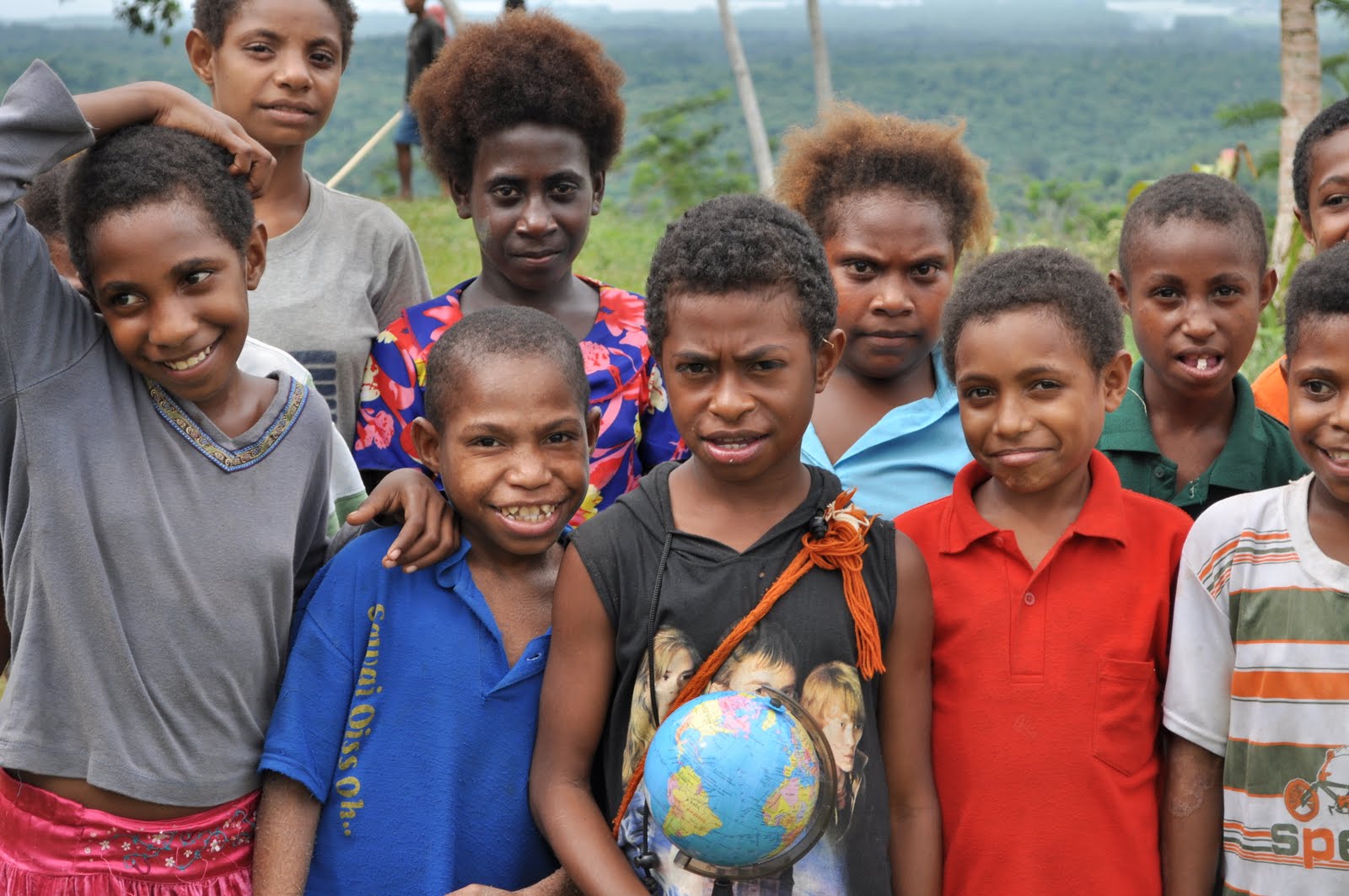
Right image: Children with the world in their hands at Brahaim Primary School.

Related sites to the Spatialworlds project
Spatialworlds website
21st Century Geography Google Group
Australian Geography Teachers' Association website
'Towards a National Geography Curriculum' project website
Geography Teachers' Association of South Australia website
Email contact
manning@chariot.net.au

Where am I??
Madang, Papua New Guinea: S: 5º 13' E: 145º 47'

A Place, Space and Environment look at Madang PNG

I have been in Madang for the past week, visiting schools, talking to geography teachers and just looking around. It has been a wonderful experience and over the next few days as I travel home I will try to put down my thoughts on Madang through the geographical lens. In the last posting I discussed the conceptual geographical pre-thinking I had on Madang. In this posting (and maybe a few following)I will try to summarise my thoughts and impressions on this amazing place through the geographical lens (in accordance with the concepts of the Australian Curriculum: Geography) discussed previously.
I intend to write an article on my journey to Madang for the geography teachers’ association journal in Australia in coming weeks and as a result will make this blog posting a dot point summary of my observations/information under the key concepts of Place, Space and Environment from the draft Australian Curriculum: Geography. Note that I have combined the concepts of Place and Environment because of the obvious entwinement of the two. More about that issue in a later blog.

Place and Environment

The Madang Province:

• is one of the largest region of Papua New Guinea
• is primarily covered in dense tropical rainforest vegetation.
• major central place is the city of Madang (population 27419)
• has a population of 365,106 (2000 census). The 2011 census is presently being conducted
• has 40% of its population under 15
• has a Crude Birth rate of 28.76 births/1,000 population, Death Rate of 8, Infant Mortality rate of 93 and life expectancy of approx 60 (58 for men and 60 for women). AIDS (208 000 in PNG will be living with HIV in 2012) and Malaria (40% of population infected) are two serious diseases in PNG.
• has a population primarily of Papuan New Guineans comprising islanders, coastal people, river people and mountain people
• is a mixture of peoples i.e. tall lithe coastal people from Karkar Island, short nuggety highlands men from Simbai and river people from the Ramu
• is on a plate boundary and has frequent earthquakes and is surrounded by volcanic islands to the North
• is composed of seven designated districts, with each district having one or more local level governments
• people have limited income with employment opportunities small, wages low and education costly (limits opportunity for those in villages who cannot afford to go to costly secondary education in centres such as Madang). Missions still play an important role in providing opportunity through education
• has the major rivers of the Ramu, Sogeram, Gogol and Malas
• the influence of missions is still evident. Signs of Christianity are quite overt in schools, shops and other institutions
• is the third leading producer of cocoa and copra and second producer of cattle. Ramu Sugar, Coconut Oil Production Manang Ltd and Jant/Gogol woodchip mill are amongst PNG's biggest employers
• seems to have few Asians in the population and the number of Europeans is minimal today. An expatriate community does still exist, working in major industries and some of the services but this is extremely small compared to the past. Most English, Europeans and US citizens living in Madang province are involved with missions or voluntary overseas aid services
• people outside of the Madang township still live in traditional houses built from natural materials and are dispersed as village settlements
• people are primarily involved in subsistence agriculture (95%). The crops grown are taro, sweet potato, betel nut, bananas, coconut and mustard plant
• major villages are along the coast and inland along the rivers and main roads. The major villages often have a primary school attached, either run by the missions or the government. Although these schools are staffed by trained teachers(most trained in Madang Province), they lack resources such as books, equipment such as computers and adequate buildings and furniture. I found that computers for student use (and teachers in most cases) are a world away and that books and writing material remain a luxury in Madang Province schools. I spent a great morning with the geography teachers at Tusbab Secondary School introducing them to GIS on their single computer in the school
•and it’s people have a strong allegiance to Papua New Guinea and are proud of their independent PNG identity. Their national anthem has pride of place in their schools
• people have the reputation of being friendly and happy. I found this to be true with nothing but hello’s, smiles and handshakes – they even asked for the photo taken! As the Russian anthropologist Mikloucho-Maclay, who lived in Male area of the province for 15 months in 1871 said, the area of Astrolobe Bay was the “Archipelago of contented people.”

Madang:

• has a Tropical climate with average temperature of 26.6 °C (average range of average monthly temperature of 1 degree) and a yearly rainfall of 3440mm with the greatest amount falling from October – May (152 days annually on which greater than 0.1 mm). April is the wettest month (439mm) and driest month.
• is fringed by volcanic material on its shore which plummets directly to the deep ocean floor. A lighthouse (memorial to the World War 2 Coastwatches) has been built on the Madang foreshore to warn shipping of this hazardous geomorphology. Along the coast of the Madang Province, the beaches are of steeply sloping weathered grey sand. Dense vegetation comprising jungle and coconuts fronts the beaches
• is the Madang Province's major port for shipping goods
• people live along the coast and surrounding islands and regularly travel by small boats (25 crowded in no more than a 8 metre fiberglass dingy powered by an outboard)
•people describe themselves as coastal people and consider that they are somewhat different to those from other areas of PNG, in particular the Highlands
• has limited infrastructure and is challenged in maintaining what it has i.e. severely pot holed city bitumen roads, transport networks (dirt roads) to villages and rubbish removal (terrible litter everywhere in Madang city) and dilapidated school buildings, to name just a few indicators
• has to the south the Bismarck Range with heights ranging over 4,000 metres. Mount Wilhelm, PNG's tallest mountain at 4509m, is found in these ranges
• is a focal point providing essential services such as banks, hospitals, schools, shops. In the countryside food markets are common place selling the subsistence crops of the villagers. These markets are also the transport hubs with villagers being trucked in by vans, utes, and trucks
• is claimed to be the tourist centre of PNG with several resorts and tourist orientated services (diving and fishing tours). Even so, due to the cost, lack of publicity and perceived ‘non-safe’ nature of PNG the tourist industry is small compared to other part of Asia and the Pacific. Although the cost was expensive, I found the people friendly, conditions safe and services adequate. Interestingly at no time as I walked around Madang or the villages in the province was I asked for money, asked to buy something, not greeted warmly or waved at
• is an aesthetically very beautiful place with sea, harbour, mountain and jungle vistas.

Space: observations related to location and distribution

Madang Province:
• is a large region of approximately 300 kilometres long and 160 kilometres wide with four large and many small offshore islands
•is to the North of Port Moresby, the capital of PNG
• is linked primarily by air and sea to Port Moresby
• has the sea on its Northern perimeter and the Bismarrck Range on its Southern
• has major rivers criss-crossing the province from south to north as they drain from the Bismark Range (Ramu, Sogeram, Gogol and Malas Rivers)
• has long term major villages evenly spaced along the south eastern coast of Astrolabe Bay (Male, Bongu, Gorendi, Garagasi, Koliku), and on the northern eastern coast of Astrolabe Bay(Bili Bili, Bogadjim, Gorima and Erima)
• the population in Madang Province is concentrated along the rivers, on the coast and on the hilltops. The population was not and is not evenly populated. Even today there are uninhabited areas of the province
• there are over 20 languages spoken just in the Astrolabe Bay area of the province which correspond with the major populated areas. Linguistically, Madang province is typified by a large number of very small language groups
•population is denser in the highland areas than in the coastal zone.

Madang:

• is located on the Northern East shore of Papua New Guinea
• is located on the Northern West shore of Astrolabe Bay
• is an indentation in Astrolabe Bay which provides a natural harbour and estuary
• is linked to Lae by a East- West road.