Monday, October 27, 2014

You said what? The spatial variance of language across Oz.


 Image above: Mapping bather language.


 Everything can be mapped

A consistent message on Spatialworlds over the years has been that you can map anything and everything. Some may say such maps (often called Map Porn) are a trivial waste of time and not worthy of geographical study.  But are they trivial? Who is to say what use a map map can be! Surely they may be useful to someone somewhere!! For example the map of lust across the US would have a use to someone, possibly!


So much of this type of social geography mapping is US based. Spatialworlds postings on spatial variance showed fascinating variance across space in the US on a very diverse and eclectic selection of 'things'. For example we can even map something like happiness in the US (see below). What would be the happiest place in Australia if we did such a map? 


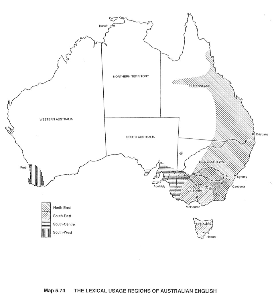
This posting highlights a few such 'trivial' social geography maps, this time from Australia. The maps relate to the variance of language use across Australia, that is different places use different words for the same things. For example, scallops or potato cakes? Swimmers, cozzies or togs? Slippery dip or slippery slide? 


In Australia there is little regional variation in accents as shown in the above regional accents map. Most people are familiar with the long “a” used by some South Australians versus the short “a” used elsewhere. However there are larger differences in vocabulary, with a number of regionally specific words. For example, an oval-shaped piece of potato that has been battered and deep-fried. These are known as potato scallops or scallops in north-eastern Australia, potato cakes in south-eastern Australia, and potato fritters in South Australia.

The article and associated maps showcased on this posting involve the creation of some maps based on the PhD thesis published in 1992 by Pauline Bryant . Bryant surveyed the word or words used to describe 72 things across all states. From the results, she identified four main regions of “lexical usage”.

Here is another two of the fascinating maps on Australian language, this time on the names of a type of processed sausage and a water dispenser.


Thanks to David Butler for directing Spatialworlds to this interesting spatial take on language.

* Whilst on about spatial variance of language in Australia, it is also worth looking at the Australian Word Map produced jointly by the ABC and the Macquarie Dictionary.


Thursday, October 23, 2014

Landsat and the power of seeing from above


Image above:  A Fantastic Landsat flyby of EarthThe Landsat program is the longest continuous global record of the Earth's surface, and continues to deliver both visually stunning and scientifically valuable images of our planet. This short video highlights Landsat's many benefits to society.


Like a bird!

This posting follows on from the recent Spatialworlds postings called ' From above' and 'Like a Bird'. In these postings I discussed the changes brought about by satellite imagery and the modern remote sensing capacity to see the Earth from above. 

"The technology of the 20th Century set in motion the age of seeing the Earth from above in all its spatial glory, an age which has changed the population’s perception of the Earth they live on."

This posting showcases the amazing imagery gathered by NASA's Landsat program. In particular the power of Landsat to map and show change over time. With Change being one of the key concepts of the Australian Curriculum: Geography, I thought it was opportune to remind us of the wonderful images provided by NASA for the geography classroom.


The Landsat program is the longest running enterprise for the acquisition of satellite imagery of the Earth. On July 23, 1972 the Earth Resources Technology Satellite was launched. This was eventually renamed to Landsat. The most recent, Landsat 8, was launched on February 11, 2013. The instruments on the Landsat satellites have acquired millions of images. The images, archived in the United States and at Landsat receiving stations around the world, are a unique resource for global change research and applications in agriculture, cartography, geology, forestry, regional planning, surveillance and education, and can be viewed through the USGS 'EarthExplorer' website. Landsat 7 data has eight spectral bands with spatial resolutions ranging from 15 to 60 meters; the temporal resolution is 16 days.


Here are some great Youtubes involving the Landsat program:


.
Celebrating this anniversary, this video is a "greatest hits" montage of Landsat data. Throughout the decades, Landsat satellites have given us a detailed view of the changes to Earth's land surface. By collecting data in multiple wavelength regions, including thermal infrared wavelengths, the Landsat fleet has allowed us to study natural disasters, urban change, water quality and water usage, agriculture development, glaciers and ice sheets, and forest health. 


This video examines two uses of Landsat data to monitor agriculture. Both wineries and timber companies rely on Landsat data to check whether their vines and trees are getting enough (or too much) water and fertilizer. The small resolution and regular repeat cycle of the satellite data is crucial to monitoring the health of their crops.

* Earth from the ISS: Watch along with Expedition 38 crew members Mike Hopkins and Rick Mastracchio as they look at various cities across the globe from the vantage point of the Cupola on-board the International Space Station 


* NASA Earth Day 2012


Wednesday, October 15, 2014

To go forth and explore - famous geographers


Image above: Famous geographers - what criteria? How many can you pick?

Related links to Spatialworlds
GeogSplace (a teaching blog for Year 12 geography)
Geogaction
Spatialworlds website
GeogSpace

Australian Geography Teachers' Association website
manning@chariot.net.au

Where am I??

Adelaide, Australia: S: 34º 55' E: 138º 36'


To explore and discover to be geographically famous

The importance of the term explore in geography is fundamental to the spirit of geography.  In the Australian Curriculum: Geography it appears often and quite purposely as an important component of 'doing' geography.  As is said in the Rationale of the curriculum:

"Geography is a structured way of exploring, analysing and understanding the characteristics of the places that make up our world..."
 

I often ask participants in my workshops  to name a famous geographer. I am usually met with blank looks, and then they hook into the explorers. Yes but no is usually my answer. This posting focuses on who are the recognised famous geographers and who are the famous who have done amazing geographical things. 

"Things like natural ecosystems, physical features, migration patterns, ethnic distribution patterns, and other facets of human-environment interaction are all the province of the geographer. Today, not many people could name a famous geographer. In the past, when much of the world was still exotic and unexplored, geographers occupied a crucial role in society."                                 Caitlin Dempsey Morais, Editor of ESRI's GIS Loungewebsite


The following site is an interesting starting point for us to explore the famous geographer.

* List of famous geographers  


This list of notable geographers is in alphabetical order enabling sorting from reputable, prominent, and well known geographers to the lesser known geographers of today.  If you want to answer the question, "Who are the most famous geographers ever?" start your search . Regardless of this search facility, few of the names are in everyday currency in the general population, let alone with young people. The names normally forwarded when people are asked to list famous geographers tend to be famous explorers such as Cook, Mawson, Magellan, Dampier etc (none of who appear on the famous geographers list). These men were either adventurers, scientists, navigators, or surveyors (in the case of William Dampier, a pirate!). By not calling them recognised geographers is not denigrating their achievements but even they would not call themselves geographers. Regardless of the classification of their expertise or background, they most definitely did geographical things using amazing geographical knowledge and skills in their pursuits.  

One such person was Alexander Von Humboldt, who was a scientist. Humboldt set off and did some amazing geographical exploration and discoveries contributing to the geographical knowledge of the world.  Humboldt, the geologist turned geographer and South American explorer was a bit of an 18th century super scientist, traveling over 24,000 miles to understand the relationship between nature and habitat. In the video, George Mehler details Humboldt’s major accomplishments and why we should care about them today.  Also have  a look at the TEDEd lesson plan to accompany the video


* Another one of my geographical heroes is the 19th Century Russian, Nicholas Miklouho-Maclay - a name that never appears on the famous geographer list - in fact his name rarely appears anywhere! He really did some amazing exploration on the cultural geography front in New Guinea, Australia and Malaysia. Miklouho-Maclay was an explorer, ethnologist, anthropologist and biologist who became famous as the first scientist to settle among and study people who had never seen a white man. Miklouho-Maclay spent the major part of his life travelling and conducted research in the Middle East, Australia, New Guinea, Melanesia and Polynesia. His geographical story for such a short life (1846-88) is truly rivetting. 


Such scientists, explorers and adventurers from the past are certainly worthy of the famous geographer tag! They don't often turn up in the famous geographer lists but they added enormously to our geographical knowledge of the world. They are heroes for students to know about and admire in the spirit of geographical exploration. These are just two of thousands of biographical stories of geographical heroes. We should be profiling them in our geography classes as real life 'Indiana Jones' types, with incredible geographical adventures to capture the exploration imagination of our students.

* Here is another list which provides further insight into the famous geographers

* ESRI have another take on famous geographers


* By the way, the most famous former geography student is Prince William (the Duke of Cambridge) of the United Kingdom who studied geography at the University of St. Andrews in Scotland; having switched from studying the history of art. Yes, a future King of England (and Australia unless...) will be a geographer. Some other interesting famous geographer information can be found on the University of Florida site (never knew that Mother Theresa was a geography teacher).

* The greatest journeys: Whilst on about exploration, here is an interesting interactive site which maps history's greatest journeys. This site is a great connecting history and geography resource.

The opposite side of the coin: the geographically inept and challenged

* Geography gaffes - certainly not geographers of fame - some amazing media geographical bloopers

* Everyone should be able to read a map
New research suggests that map reading is a dying skill in the age of the smartphone. 

Wednesday, October 8, 2014

Geographical lesson starters


 Image above: An amazing adventure geography video.  The Ridge is the brand new film from Danny Macaskill... For the first time in one of his films Danny climbs aboard a mountain bike and returns to his native home of the Isle of Skye in Scotland to take on a death-defying ride along the notorious Cuillin Ridgeline.

Related links to Spatialworlds
GeogSplace (a teaching blog for Year 12 geography)
Geogaction
Spatialworlds website
GeogSpace

Australian Geography Teachers' Association website
manning@chariot.net.au

Where am I??

Adelaide, Australia: S: 34º 55' E: 138º 36'


Just geographically interesting to look at as a lesson starter, maybe!

Unlike most Spatialworlds postings, this posting has no theme. Rather it is just a selection of some geographically interesting sites, such as the application of spatial technology, the cultural transitions to adulthood, mapping names over time in the UK, to some interesting social geography from Venezuela.


* Images of change from NASA


Each week the NASA State of Flux gallery features images of different locations on planet Earth, showing change over time periods ranging from centuries to days. Some of these effects are related to climate change, some are not. Some document the effects of urbanisation, or the ravage of natural hazards such as fires and floods. All show our planet in a state of flux.


For example, look at the changes above caused by the recent Volcanc eruption in Papua New Guinea. Mount Tavurvur, on Papua New Guinea's New Britain Island, erupted on August 29, 2014, throwing ash (gray-brown areas of September image) over surrounding areas. Its last major eruption was in 1994. Tavurvur is a stratovolcano, a volcano consisting of alternating layers of lava and ash, and is located along the eastern edge of the Rabaul Volcanic Complex. Simpson Harbor forms part of the much larger (mostly submerged) Rabaul Caldera.

An interesting spatial application on the flow and change of air traffic in the UK.  

Some interesting popular name maps in the US over time. Diversity and change in names is always fun to look at!

Some disturbing cultural geography

In Venezuela, women are confronted with a culture of increasingly enhanced physiques fueled by beauty pageants and plastic surgery.

Cultural diffference across space re: breastfeeding

Continuing the quirkiness of body perception theme from culture to culture, it is clear that breastfeeding can be a polarizing topic. Views vary not only from person to person, but also country to country, according to a new survey examining women's opinions on breastfeeding.


Population turn around on predictions

In a paper published recently in Science, demographers from several universities and the United Nations Population Division conclude that instead of leveling off in the second half of the 21st century, as the UN predicted less than a decade ago, the world's population will continue to grow beyond 2100.


Using spatial technology to fight crimes

Authorities use Google Earth to crack down on illegal activities. This is a useful platform to discuss the ethics involved in using geospatial technologies, the expectations of privacy and issues of governance.  This could also be used to discuss urban political geography and principles of planning.  What are the limits to the legal and ethical uses of technologies?


* The Burning Man festival - a unique cultural event transforming the landscape for a few days

The Burning Man Festival takes place at the end of August every year in the barren and remote Black Rock Desert of Nevada. The weeklong festival is described by its organisation as “an experiment in community, art, radical self-expression, and radical self-reliance.” Earth-bound photographers have chronicled the legacy of art, technology, design, and fashion at the event over the years, but Skybox wanted to know if they could capture the transformation of the city from space, with their constellation of SkySats.


Coming of age traditions around the world

The transition from childhood to adulthood -- the 'coming of age' of boys who become young men and girls who become young women -- is a significant stepping stone in everyone’s life. But the age at which this happens, and how a child celebrates their rite of passage into adolescence, depends entirely on where they live and what culture they grow up in.


Image above: In Vanuatu, a small island nation in the middle of the South Pacific, young boys come of age by jumping off of a 98-foot-tall tower with a bungee-like vine tied to their ankles.

* Fragile states

The Fragile States Index interactive index and map focuses on the indicators of risk and is based on thousands of articles and reports that are processed by the CAST Software from electronically available sources.


Weak and failing states pose a challenge to the international community. In today’s world, with its highly globalized economy, information systems and interlaced security, pressures on one fragile state can have serious repercussions not only for that state and its people, but also for its neighbors and other states halfway across the globe.  The Fragile States Index (FSI), produced by The Fund for Peace, is a critical tool in highlighting not only the normal pressures that all states experience, but also in identifying when those pressures are pushing a state towards the brink of failure.

* What does the Earth look like?

This video covers various topics important to mapping and satellite imagery.  There is so much more to the world and space than what we can see see.  Chromoscope, referenced in the video, simulates other forms of energy on the electromagnetic spectrum besides just visible light.  This type of information is at the core of the science behind all of our satellite imagery.  This video also covers many map projection issues and highlights online resources to understand map distortion including:

Wednesday, October 1, 2014

Grammar and vocabulary of geography


Image above:The Kids World Citizen site posting on fundamental geographical knowledge all students (and teachers) should have.

Related links to Spatialworlds
GeogSplace (a teaching blog for Year 12 geography)
Geogaction
Spatialworlds website
GeogSpace

Australian Geography Teachers' Association website
manning@chariot.net.au

Where am I??

Adelaide, Australia: S: 34º 55' E: 138º 36'


Knowledge required for understanding

 "If we were to imagine learning to think geographically to be a bit like learning a language, then we need both geographical vocabulary and grammar in order to do this. The subject's 'core knowledge' can be thought of as geography's vocabulary – the extensive, factual basis of the 'world subject'. If core knowledge is geography's vocabulary, geography's conceptual framework forms its grammar."                                                                         David Lambert


This posting is dedicated to the thinking of David Lambert, former Geography Association of the UK CEO and presently the Professor of Geography Education at the Institute of Education, University of London. In his numerous articles David has referred to the grammar and vocabulary of geography. I have found this way of thinking extremely useful when working with teachers not fully acquitted with the nuances of geographical education. David's approach to professional learning through this analogy is quite fascinating and very helpful in structural learning approaches with teachers. In a nutshell, the analogy is that the conceptual thinking of geography can be viewed as the grammar of geography and the exhaustive knowledge, language and skills of geography as the vocabulary.  Without the so called vocabulary, as teachers we are restricted in developing deep geographical understandings through the thinking in geography, the grammar. 

Some associated thinking on the need to teach the vocabulary of geography relates to the area of citizenship education. Some argue, and I agree, such basic geographical knowledge, understandings and skills are imperative for young adults to know, so that they can navigate society as a citizen. In a previous Spatialworlds blog I explored this idea in a posting called Spatial citizenship.  


A slide from my Geographical Knowledge workshop

I consider such a view as extremely pertinent to where we are at with the professional learning of teachers in geography in Australia.  Teachers are engaging with the structure and content of the curriculum, but without sound geographical knowledge and skills they are limited in developing the deep geographical understandings and thinking which is implicit in the Australian Curriculum: Geography Achievement Standards. In fact, I think the application of the Achievement Standards is virtually impossible without the grammar and vocabulary as enunciated by David.

So what is the 
vocabulary of geography? In recent months I have started conducting geographical knowledge workshops with teachers as a follow-up to the geographical grammar (thinking) workshops I have been conducting since 2012. Interestingly I came across a blog posting from the other side of the world today which eerily reflected almost exactly the workshops I have been conducting. Such a coincidence was affirming that there is some core knowledge that geography educators can relate to as foundation and essential knowledge as the vocabulary building stones.

Here is a slide showing a broad outline of what I cover in the geographical 
vocabulary workshop  


Now have a look at the blog posting on the area of essential geographical knowledge (vocabulary) from the Kid World Citizen site - interestingly similar!
Having said all of that, the challenge for geography educators involved in conducting professional learning for teachers is to present such material 
in an interesting and accessible manner, in a short timespan and not to come across to adult learners as treating them like Geographical ignoramus’s’!

Download the attached flyer from Dropbox if you or any of your colleagues are interested in attending any of the Geographical Grammar and Knowledge workshops in South Australia during the remainder of this year or in 2015.