Showing posts with label Change. Show all posts

Wednesday, November 26, 2014

Getting better all the time: Sunshine geography


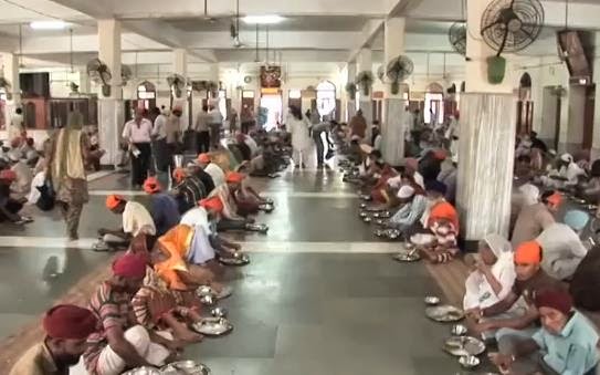
Image: A good news story: The Golden Temple is the holiest shrine of the Sikh religion. It is also home to one of the largest free eateries in the world.


In a previous posting I explored the idea of Geogphobia and the need for some 'sunshine geography' to engage students in the WOW (World of Wonder) of geography.  Such an approach is not denigrating the importance of students addressing geographical issues and problems but is saying that we should not start with the deficit model but have students see the wonder of the world before exploring issues.
It is impossible as a citizen not to avoid the bad news in the media - it feeds on it!! The classroom needs to be much more strategic when we are working with the development of values, attitudes and perspectives related to the fragility and dynamism of our world. The negativity of the 24 hour news cycle in relation to the environment came home to me recently at a workshop when I asked participants the question; "how much of South Australia's energy needs come from wind energy?" Most participants guessed that it was about 5-10%. In fact, in 2014 South Australia generated up to 30% of its energy needs from wind power and in July this year enough electricity was generated from wind farms to meet a record 43 per cent of the state’s power needs, and on occasions during the month provided all the state’s electricity needs. Even more impressive is that the combination of wind energy and rooftop solar has provided more than 100 per cent of South Australia's electricity needs for a whole working day between 9.30am and 6pm several times over recent months .

Now that is a South Australian good news story! On those same days wind energy accounted for 12% of Victoria's energy needs - also impressive considering Victoria's energy needs!


                               Interactive daily South Eastern Australia wind energy map

On the theme of the media only focusing on bad news in relation to the geographical world (a phenomena called death geographies), I thought the following article from Business Insider Australia was incredibly pertinent. 

OK, Haters, It's Time To Admit It: The World Is Becoming A Better Place 

"Some people love to complain about how horrible everything is all the time. And there are certainly plenty of horrible things to complain about. People are mean, for example. And people get sick. And there are horrible accidents and injustices and tragedies and unfairness everywhere. And there is Ebola. However it is nice sometimes remind ourselves that some things — many things, in fact — are getting better all the time. "


Over at the Oxford Martin School, Max Roser has put together a provocative article and presentation entitled, “It’s a cold hard fact: Our world is becoming a better place.”
Roser includes lots of facts that will drive the haters crazy and show that our world is becoming a better place. What follows are a range of graphs over time showing change in health, wars, poverty, feeding of populations, democracy and political freedoms around the world. The trends are all downward ... but are they just clever use of statistics?

* War and battles have declined over time

* The Visual History of the Rise of Political Freedom and the Decrease in Violence


* Health 


(The Our World in data has an amazing number of visualisations on world health)

* Feeding the world


Poverty


  * Democractisation of the world


Our World in data - great visualisatons to show change  
The visualisations above relating to good news stories have come from the excellent site by Max Roser called 'Our World in data'. Max Roser, is a James Martin Fellow researching income inequality and inclusive growth at the Institute for New Economic Thinking, Oxford Martin School. Of particular interest is that much of the visualisations on this site are perfect for some of the geographical thinking in relation to the Change concept of the Australian Curriculum: Geography - to show that change is not always a deficit as we study geography. However there are also plenty of visualisations on the site to show that things are not getting better i.e forest cover and CO2 emissions

Roser explains the thinking behind his OurWorldInData.org online resource:

"Is it actually true that we are building a better world? Or are those who claim that things are always getting worse the ones in the right? Whether we're discussing the way of the world over a pint in the pub or dissecting the issues at an academic conference, it’s a topic that lingers constantly: how is the world changing?
The evidence to answer these questions is out there, but it is often obscured by media headlines. So we created OurWorldInData.org to present long-term data on how our world is changing. Using empirical data, visualised in graphs, we tell the history of the world that we live in, looking at long-term economic, social and environmental trends. For each topic the quality of the data is discussed and comprehensive lists of the data sources are provided, giving a trustworthy and transparent starting point for researchers.
The evidence shows that we are becoming less violent and increasingly more tolerant, that we are leading healthier lives, are better fed, and that poverty around the world is declining rapidly. Taking these facts into account paints a very positive picture of how the world is changing."

.

Thursday, October 23, 2014

Landsat and the power of seeing from above


Image above:  A Fantastic Landsat flyby of EarthThe Landsat program is the longest continuous global record of the Earth's surface, and continues to deliver both visually stunning and scientifically valuable images of our planet. This short video highlights Landsat's many benefits to society.


Like a bird!

This posting follows on from the recent Spatialworlds postings called ' From above' and 'Like a Bird'. In these postings I discussed the changes brought about by satellite imagery and the modern remote sensing capacity to see the Earth from above. 

"The technology of the 20th Century set in motion the age of seeing the Earth from above in all its spatial glory, an age which has changed the population’s perception of the Earth they live on."

This posting showcases the amazing imagery gathered by NASA's Landsat program. In particular the power of Landsat to map and show change over time. With Change being one of the key concepts of the Australian Curriculum: Geography, I thought it was opportune to remind us of the wonderful images provided by NASA for the geography classroom.


The Landsat program is the longest running enterprise for the acquisition of satellite imagery of the Earth. On July 23, 1972 the Earth Resources Technology Satellite was launched. This was eventually renamed to Landsat. The most recent, Landsat 8, was launched on February 11, 2013. The instruments on the Landsat satellites have acquired millions of images. The images, archived in the United States and at Landsat receiving stations around the world, are a unique resource for global change research and applications in agriculture, cartography, geology, forestry, regional planning, surveillance and education, and can be viewed through the USGS 'EarthExplorer' website. Landsat 7 data has eight spectral bands with spatial resolutions ranging from 15 to 60 meters; the temporal resolution is 16 days.


Here are some great Youtubes involving the Landsat program:


.
Celebrating this anniversary, this video is a "greatest hits" montage of Landsat data. Throughout the decades, Landsat satellites have given us a detailed view of the changes to Earth's land surface. By collecting data in multiple wavelength regions, including thermal infrared wavelengths, the Landsat fleet has allowed us to study natural disasters, urban change, water quality and water usage, agriculture development, glaciers and ice sheets, and forest health. 


This video examines two uses of Landsat data to monitor agriculture. Both wineries and timber companies rely on Landsat data to check whether their vines and trees are getting enough (or too much) water and fertilizer. The small resolution and regular repeat cycle of the satellite data is crucial to monitoring the health of their crops.

* Earth from the ISS: Watch along with Expedition 38 crew members Mike Hopkins and Rick Mastracchio as they look at various cities across the globe from the vantage point of the Cupola on-board the International Space Station 


* NASA Earth Day 2012


Sunday, July 17, 2011

Creating the picture through other no less important concepts


Left image: Bongu; Mikloucho-Maclay's paradise.
Right image: Ashore at Bili Bili, home of the pottery in the Madang Province.

Related sites to the Spatialworlds project
Spatialworlds website
21st Century Geography Google Group
Australian Geography Teachers' Association website
'Towards a National Geography Curriculum' project website
Geography Teachers' Association of South Australia website
Email contact
manning@chariot.net.au

Where am I??
Melbourne, Australia: S: 37º 47' E: 144º 58'


Madang through the concepts of Change, Interconnection and Sustainability

In the last posting I painted an initial geographical picture of Madang, PNG through the concepts of Place, Space and Environment. In this posting I will add to the complexity and richness of the geographical picture of Madang through the no less important concepts of Change, Interconnection and Sustainability. As mentioned previously in the Spatialworlds blog, these are three of the seven concepts identifed by the draft Australian Curriculum: Geography which will soon be on-line for public consulatation(August-September 2011). In the meantime I have been writing these blogs on Madang to see if these concepts provide the richness and coverage as key geographical concepts for valid, elaborate and interesting geographical thinking.

More questions than answers but worth of geographical exploration and thinking

* Change

• Human contact with the New Guinea mainland has extended through the past 50,000 years
• The first European to spend any length of time on the PNG mainland was Russian biologist Nicolai Miklouho-Maclay. He arrived at Astrolabe Bay, south of the present site of Madang, in 1871 and stayed for 15 months
• Madang was first colonised by the Germans in 1884 (German New Guinea Company) arrived and tried to establish a base at various locations including at present day Madang but were continually beaten by malaria. They eventually moved to Rabaul. When in the province they established a settlement, developed plantation and built roads (the German presence can still be seen in the remnant plantations, old deserted settlements and various place names). The Lutheran Mission arrived during this time and Finschhafen remains a Lutheran base.
• The Commonwealth of Australia assumed a mandate from the League of Nations for governing the former German territory of New Guinea in 1920.
• The Japanese invaded and captured Madang without a fight during World War II in 1942. In September 1943, Australian forces launched a sustained campaign to retake the Finisterre Range and Madang. The town was captured on April 24, 1944. During the occupation and fighting the town was virtually destroyed and had to be rebuilt afterwards.
• Due to changes caused by outside contact over the years, cultural loss has been great but isolation of many groups has caused that rate of change to be diversely uneven.
• Australian administration had an enormous impact on Madang with Australian administrators, companies, patrol officers, health workers and teachers contributing to the growth and welfare of the country. This influence, with the continuing influence of the Lutheran Mission as a legacy of the German colonisation are clearly seen in aspects of Madang life today. Non-religion overseas volunteer organisations such as VSA also continue to play an important role in the life of the Madang Province.
• PNG and subsequently Madang gained independence in 1975 and has been challenged to maintain services and growth for its people since. PNG still receives % of Australian aid and Australian companies continue to be active in a diverse range of industries.

Interconnection

• The 2007 opening of the spur to the Highlands Highway between Lae and Madang linked Madang by road to Lae and the mountain spine of the PNG Highlands. This connection has had a great impact on the nature and population of the area and the movement of people between the Highland mines and Madang. It has meant that villages from the Madang province can more easily come in to Madang for supplies and gatherings and Papuan New Guineans from others centres and areas can easily migrate to the town. This has put pressure on services in Madang and many consider peaceful and safe Madang may be blighted with some of the crime and lawlessness experienced by centres such as Lae. The highway linkage has also had the impact on people from the Madang area traveling and working in the mines and timber industries in the Highlands with the associated changes to family, community and economic structures in the Madang Province.
• Sea transport still remains a crucial link for villages traveling from coastal areas to Madang. The movement of people by sea is a prominent and visible industry in the Madang area.
Foreign investment and the connections with foreign nationals including Australian and Chinese.
• PNG still has strong connections with Australia through AusAID and the churches still operating missions, schools, colleges/universities etc in areas such as Madang.
• Even though most of the population lives in poverty (or subsistence) many have mobile phones due to the inroads of the Irish company Digicel. This is an amazingly cheap communication technology where a person can buy a mobile phone for 20 Australian Dollars with phone calls of only 20 cents/minute locally and 60cents/minute to Australia (no connection fees or monthly bills). What is the status, economic and social impact of such connections for people with little possessions other than a mobile phone. There are Digicel advertisements and top-up places everywhere in Madang!
• Internet is only in two places in the Madang province; The Divine Word University and the Madang Resort (not even at the high school yet but they say it is coming next year). The lack of Internet for local in 2011 in such an area except for foreigners is surprising. What will be the impact on Madang Province in terms of interconnections when it is available?

* Sustainability

The issue of environmental, social, economic and political sustainability of the Madang province is influenced by factors such as:

* Environmental sustainability
• Volcanic and earthquake activity. Offshore islands, in some cases volcanic, with Karkar, Bagabag and Manam being notable. In 2004/2005 the population of Manam Island was evacuated due to an eruption of the volcano. Bagabag and Karkar have had no major volcanic activities in recent years. This active volcanic region is part of the Pacific Ring of Fire and has created crater lakes, smoking volcanic cones and black sand beaches.
• Timber milling and the clearing of forests.
• Erosion of soil by the clearing of forests for Palm Oil production.
• Slash and burn technology still used by villagers to sustain the soil. Constant smell of burning evident.

* Economic sustainability
• Infrastructure – pot holes, rubbish, limited public works and facilities (including education resources and provision).
• Impact of foreign investment and companies.
• Impact on subsistence agriculture of land being used for commercial crops such as Palm Oil.

* Social/cultural sustainability
• Outside contact over the years has led to cultural loss in major settled areas of the province. However due to isolation many groups has caused that rate of change to be diversely uneven.
• The cost of education and the opportunity for employment.
• Impact of males leaving province seeking work.
• Impact of employment opportunities for women in resorts.
• Impact on social structures in villages if subsistence agriculture is threatened by commercial crops.
• Impact of almost everyone having a mobile phone on social structures.

*Political sustainability
Governanceimplied corruption