Thursday, November 28, 2013

Spaced out! Variance across space


The uniqueness of places - Variance across space

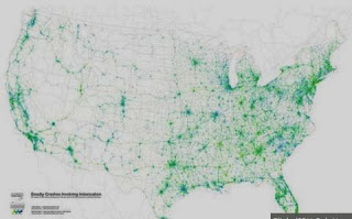
An importance aspect of spatial literacy is an understanding of the variance across space and between places of all aspects of the physical and human world. No two places are the same and whenever geographers create a map they are inquisitive about how the aspect mapped varies from places to place across space. Whether talking about soils, vegetation, religion or attitudes, it is the thing that makes every location of the earth unique. In fact, geographers go further than just map and discuss variance across space, they are curious about the reasons for the variance. Why is this place different to all other places - the "why is it so?" question. 
The following collection of maps provide some great starting points for describing and explaining variance across space - from aspects as diverse as language, gay marriage, gun crime, happiness to hate. Whilst looking at these maps of variance it is worth harking back to the previous Spatialworlds posting on distributions and patterns.  These maps certainly show some fascinating distributions and patterns, very difficult to explain without some research or local knowledge.
Many of the examples below are US based.  it seems that the Americans are way ahead in this area of creating maps and visualisations using data of many forms to create  a representation to inform perceptions and discussion on a wide range of often quirky topics.


To interpret variance we also need to consider projections and scale.  Here are just two interesting links on these two aspects of visualisation and representation.


Sunday, November 24, 2013

David Lambert 'nails' the thinking on geography


Image above: Professor David Lambert presenting at AGTA 2013 in Perth.  The 'essence of geography' according to David - Inspiration with a message. 


Where am I??  
Adelaide, Australia: S: 34º 55' E: 138º 36'


"Without geography, the world would be a mystery to us. Geography is the subject that contributes more than any other to young people’s knowledge of the world." 
Professor David Lambert 

At AGTA 2013 in Perth in January this year I had the pleasure of introducing Professor David Lambert to the conference. David soon won the hearts and minds of the delegates by his inspiring and thought provoking address (click here to view David Powerpoint from his presentation).  As a result I thought it opportune to put this posting together highlighting the fantastic work of David in promoting geography in the UK and beyond. We were indeed lucky to have him travel down here to share his passion and thinking on geography this year.

David Lambert is the former Chief Executive of the Geographical Association and presently  the Professor of Geography at the Institute of Education, University of London. The focus of his work is very much in the areas of pedagogy, assessment and citizenship in school geography.  As the CEO of the Geography Association (GA) of the UK, he was the main architect of the Geography Manifesto: A Different View which set out the mission for geography into the future in the UK. The Manifesto made a compelling case for geography's place in the curriculum. A Different View, and the supporting materials on the GA website, are designed to be used in any context where geography is taught, explained, encouraged or promoted. The Different View video is certainly worth a look, as is David's Right here, Right Now video on geography.


The following are some writings and videos from David which give a real insight into his thinking about geography, and much much more when talking about education!

* Telegraph article


“Teachers should seize this chance to get stuck into the knowledge question rather than collectively avoid it, which has in some ways been the story of recent times. The professional language invented over the past 10 years is the language of pedagogy. 
This is no bad thing in itself, of course, but pedagogy has become so dominant that it is now confused with its apparently weaker cousin: curriculum. But it is the curriculum that teachers need to engage with.”

* Video of David on geography

“A person growing up in the 21st century as a global citizen (and all that implies) is at a disadvantage without geographical knowledge – economically, culturally and politically. How can we make any of the personal decisions that already confront us every day about energy, food and water security without geographical knowledge?
Understanding geographical perspectives contributes to our capabilities as educated individuals and members of society.”

* David on school geography


If this posting has wet your appetite for 'Lambert think' on geography, make sure you follow David's stimulating geography blog called Impolite Geography.  Every posting provides some great food for thought with 'left field' ideas and approaches to thinking about modern geography in our schools.

Wednesday, November 20, 2013

Looking for distributions and patterns


Where am I??  
Adelaide, Australia: S: 34º 55' E: 138º 36'

Can you see a distribution and/or pattern?

In the Inquiry and Skill Strand of the Australian Curriculum: Geography there is frequent reference of the geographic skill of identifying distributions and patterns when studying visual representations of geographical data. As stated in the Year 7 Skill Stand under the Interpreting, Analysis and Concluding stage of Inquiry, students are to  be able to:

"Analyse geographical data and other information using qualitative and quantitative methods, and digital and spatial technologies as appropriate, to identify and propose explanations for spatial distributions, patterns and trends and infer relationships."

The visual representations of maps, graphs and images (remote sensed images or pictures) we use in geography provide the opportunity to identify distribution, patterns and trends. In fact, such a skill is at the core of understanding and applying the Space concept in the curriculum.  As is stated in the Organisation section of the on-line curriculum.  

"The concept of space is about the significance of location and spatial distribution, and ways people organise and manage the spaces that we live in."

Most importantly we do not just want students to describe the distributions and identify the patterns but also try to explain the 'why' of the distributions and patterns through the geographical data and representations they use.


Here are just some of the great representations available on-line. Go to my Spatial Literacy Scoop.it for a extensive curation of such maps. 

We think of slavery as a practice of the past, an image from Roman colonies or 18th-century American plantations, but the practice of enslaving human beings as property still exists. There are 29.8 million people living as slaves right now, according to a comprehensive new report issued by the Australia-based Walk Free Foundation.


The Geography of drunk driving – patterns not easily explained by density of cars alone!


A series of maps of India helping to see patterns to birth control success.


* From the past: As mentioned previously in a Spatialworlds posting on John Snow's work, finding patterns through maps for the betterment of society is nothing new. Here is John Snow’s Cholera map from the 19th Century recreated with modern spatial technology.


* Maps to never forget 
Finally here are a whole lot of maps of things from daily fat intake, alcohol consumption, marriage rates to happiness levels. The maps are a great resource for students to identify and hopefully explain distributions and patterns through maps. Here are just a few


There are so many more maps of this ilk on-line for use in the classroom. Such maps are often referred to as Map Porn because of their quirky and seemingly useless nature beyond stimulation (however every map is likely to be useful to someone!). One thing is for sure, they are growing rapidly in number and are potentially a great resource for the classroom to engage students in mapping, to learn about aspects of their world not often studied and to develop the skills of identifying and explaining distributions and patterns.

Tuesday, November 12, 2013

Thinking about thinking geographically


Continuing to think about geographical thinking

During this year during workshops on the Australian Curriculum: Geography I have spent considerable time helping teachers to define geography and the nature of geographical thinking in the classroom. This has involved using the 7 concepts of the curriculum to help articulate ‘what makes geography geography?’ Recently I came across an excellent article from the National Geographic people that cited the following aspects of looking at something which make it a geographical look. The aspects are:

* Interaction: systems interacting
* Connexion : people with place and between each other
* Implication: how we interact with the world and make decisions
The article says that such a look helps develop the geography literacy of students. That is, develop ‘their ability to use geographic understanding and geographic reasoning to make far reaching decisions.’

Although not the Australian Curriculum: Geography key concepts, there is an obvious synergy between these three aspects and what is being promoted as geographical thinking in the Australian Curriculum: Geography. Go to the Australian Curriculum portal for details on the 7 concepts.

Needless to say that the 7 key concepts of the curriculum; Place, Space, Environment, Change, Interconnection, Sustainability and Scale are proving extremely useful in supporting teachers to think geographically.


 Concept Wheel: Copyright Malcolm McInerney 2012

Using the Concept Wheel above, the workshops have been a fun away to work with teachers in deconstructing and distilling what geographical thinking (and geography) is all about. 

What stimulated this posting is that I recently came across the poster shown at the beginning of this post. It was a really interesting take on visually showing what geography involves and certainly provides plenty of ideas and angles to discuss about geographical thinking. I will certainly use it to help teachers to make sense of geographical thinking in the future.