
Spatial Worlds Website
Picture descriptions:
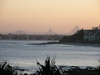
Left image: Glasshouse Mountains from Caloundra.
Right image: Brisbane from the air.
Caloundra: S:26º 81' E:153º 12'
AGTA 2008 Conference in Queensland
As always conferences are a great time to get new ideas and have the time to look at some new websites. The AGTA Conference on the Sunshine Coast from September 28th to October 2nd was no exception. In this blog entry I will describe six things that I found of interest and immediate use.
1. A reducing world: using technology to bring the world into your classroom by using the iEARN and Take it Global website.
iEARN (International Education and Resource Network) at http://www.iearn.org/
iEARN is the world's largest non-profit global network that enables teachers and youth to use the Internet and other technologies to collaborate on projects that enhance learning and make a difference in the world.
Some useful sections of the site:
Carbon footprint http://of2.iearn.org/
Our Footprints, Our Future!" is an international initiative that encourages youth (ages 19 and younger) from around the world to use online tools and resources to measure their carbon footprint and develop ways to reduce their carbon usage. The goal is for one million students around the world to join together with their families, their schools, and their communities to reduce the total global carbon footprint.
Register now for Oct 13 - Dec 15, 2008 session of iEARN Online Professional Development Courses for educators. iEARN's 9-week courses bring together participants from around the world to develop plans and techniques for integrating global projects into the classroom. http://www.iearn.org/professional/online.html
Taking it global at
http://www.takingitglobal.org/tiged/
TakingITGlobal.org is an online community that connects youth to find inspiration, access information, get involved, and take action in their local and global communities. It's the world's most popular online community for young people interested in making a difference, with hundreds of thousands of unique visitors each month. TIG's highly interactive website provides a platform for expression, connection to opportunities, and support for action. Join now and connect with thousands of other young people around the world.
Media literacy booklet http://www.takingitglobal.org/tiged/
As media becomes more digital, everyone needs to learn how to get the most out of what they read, watch and listen to. TIGed's new Digital Media Literacy Primer is a great way for teachers to bring important information into their classrooms. With explanations of great online tools and suggestions on how to teach with them
Understanding issues section at http://www.takingitglobal.org/understand/
This section of TakingITGlobal helps you inform yourself about pressing global issues, and lets you explore TIG's Featured Theme archive
Games and fun at http://www.takingitglobal.org/games/
The flag game at http://www.takingitglobal.org/games/flag/ is worth a look for Geography classes.
2. The Cluster search engine at http://clusty.com/
If you are sick of searches on the Internet where you get pages and pages of unsorted finds. The Clusty search engine is your answer! Clusty sorts your search into clusters or categories. For example if you type in GIS you get the option on the left side of the results to view the jobs in GIS, countries and GIS, free GIS options, GIS portals, GIS history and many more categories. What a great facility to isolate your search requirements. If that doesn’t make sense just do the search and it will show you the potential of this engine for your searches.
3. The Picasa web image library at http://picasa.google. com/
This program can be downloaded free and is a great way to store your images on the web. Picasa enables you to organise your photos and store them in one place, edit your photos, create movies/collages/slideshows etc and to share the photos via web albums.
To compliment the Picasa program open up a Google account (if you have not already) and start using a Picasa web album http://picasaweb.google.com/home . The use of the Picasa web library is an imperative if you intend to upload images into Google Earth or Google maps. These programs only load images from the web and not from your hard drive.
4. Google SketchUp at http://sketchup.google.com/index.html is a great program to create 3D objects such as buildings and landscape objects. What is really amazing is that these 3D objects can then be imported into Google Earth as buildings etc. The program is easy to use, has excellent instructions for use and is an ideal educational tool to add 3D dimensions to mapping projects. The K-12 Education page is of particular use to the geography teacher interested in SketchUp.
5. Eduspace at http://www.eduspace.esa.int/eduspace/main.asp?ulang=en has some great images and educational materials. As usual well worth the look.
The EduSpace-site aims to give to the youth of Europe a portal to space applications and in particular to a wide-spread visibility of Earth Observation as co-ordinated by the European Space Agency (ESA) and its European and National Partners.
6. 3D in Google Earth at http://earth.google.com/
We have all played with Google Earth by now but I was surprised by the new 3D capability as evidenced at Uluru. A real addition is the ability to map a path and fly around in Google Earth via the flight simulator. While talking about virtual flight, check out the Microsoft Flight Simulator at http://www.microsoft.com/games/FlightSimulatorX/ This site is a flight game with realistic terrain, scenery and weather to deal with.
These are just a few of the gems I brought back from the conference and now need to learn how to use and apply to the classroom for teachers. If you want to view the conference presentations go to the AGTA site at http://www.agta.asn.au/conf08/presentations.htm
Well done to Bec Nicholas and David Lergessner for a great conference.